

Summary:
The Whole Enchilada is possibly one of the best mountain bike rides in the world. While it's not always possible to do the entire ride due to weather conditions it's worth checking out. We love it because of all of the environmental diversity you'll experience on your ride.
Category: Trails
All of the individual segments wrapped up into one
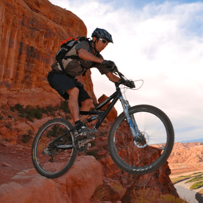
The Whole Enchilada (WE) is a true back country experience mountain biking adventure. It is arguably one of the best mountain bike rides in the world. Not only for the vast array of differing trail terrain itself but for itʼs rare beauty and interaction with three different eco-systems.
Mount your beast at the Parking area / bathrooms on Geyser Pass Road.
After a steep bear of climb to get your blood pumping you will start descending through a high alpine forest, wind through aspen trees, cross streams, reach a lake, drop into the high desert with Castle Valley in the view. Followed by drops, chunky ledges, sand flowing single track down to the Valley bottom and the Colorado river there is no other trail system like it. With thatʼs said, Be sure you come prepared with enough food and water, and a good map. You should familiarize yourself with the various bail-out options in case of a mechanical, you bonk, or if the day gets too hot to continue.
The WE trail system encompasses several trails including:
Burro Pass, Hazard County, Kokopelli, UPS, LPS, Porcupine Rim Classic, Lower Porcupine Singletrack
Please respect all trail closures and confer with the local shuttle companies to find out where they can drop you off depending on the current conditions. Trails are easily damaged when they are ridden when wet or snow covered.
Assuming you have taken the commercial shuttle option, you'll begin riding from Geyser Pass in the LaSal Mountains. Hop onto the Geyser Pass – Burro Pass trail which starts just behind the pit toilet at the parking area.
Once you hit the road again, turn left and the trail will change to singletrack (Burro Pass Trail #315). Climb hard as the oxygen rarefies. Reach the above-treeline pass at 11,150-ft and catch your breath for the spectacular down that is about to start. The section of trail dropping from Burro Pass is narrow, has tight switchbacks, steep grades, sharp rock and slippery roots through a damp evergreen forest. There are occasional stream crossings. It's a bit much for many riders, so don't feel bad if you have to walk a fair bit for a while.
Eventually, the singletrack rejoins dirt road and you contour around through aspen glades, alternately climbing then dropping, until you reach scenic Warner Lake. From the lake, continue contouring around until you reach the start of Hazard County. Climb the stout hill at the beginning of this trail, then drop singletrack through the Gambel Oak hillside. This trail is not as hairball as it was when it was illegal, but there are still plenty of armored features, including gap jumps. You can hit them, or not, as your conscience dictates–the trail allows for both.
Hazard spits you out on the Lasal Mountain Loop road. Cross over and descend the Kokopelli Trail, a warp-speed dirt road that leads you onto the southwest wall of Castle Valley: the Porcupine Rim Classic. The road begins to diverge from the developing rim as you cross a small cattle guard ride-over through a fence. The guard is your signal to watch out for a singletrack exiting right to hug the rim: this is UPS (Upper Porcupine Singletrack). Take the singletrack, or, if need be, bail out down the Kokopelli Trail to Sand Flats road.
UPS climbs a bit, then begins to roll along the Porcupine Rim Classic, eventually connecting to the somewhat more technical LPS (Lower Porcupine Singletrack). UPS and LPS are the favorite part of the Whole Enchilada for most riders, with ledges, swooping turns, tricky little drops and slickrock sections through Ponderosa and Pinyon/Juniper forest. Here, beside the abrupt scarp of the Porcupine Rim Classic, the views are astounding. While mostly very rideable, there are some ridiculously difficult features in these two trail segments, like the (optional) Notch.
While technically, you can ride both directions and session the tricky bits, in reality, this is a busy, de facto downhill trail, so be forewarned! Come at an off-time if you want to dawdle. Come early (be first) if you want to dive-bomb it.
The singletrack ends at the view point where the traditional Porcupine Rim Classic trail climbs up to join the rim. Continue out the Porcupine Rim Classic jeep road, which is ledgy, fast and fun. It hugs the rim for a while, then deviates to the left to find a way down off the mesa. Passing through various rock levels yields fun drops and slickrock sections.
Eventually, the road narrows to singletrack again as the trail enters Jackass Canyon to descend through major cliffs to the Colorado River. This is (or was) the most technical part of the ride, though recent modifications have destroyed much of the challenge in this classic test-piece. Please write to Grand County to request that they stop modifying existing trails that have been world-class attractions for 30-years.
Reaching the river, join the jaw-dropping new bike path leading back to town. Due to the narrowness of the road corridor between the cliffs and the river, this path is built for part of its length on expensive elevated pilings! Where it runs on the actual roadbed, there is a separating curb. The path joins with the Moab Canyon bike path out to Arches and I-Sky at the highway. Praise the Lord! Mention how great this is in your letter to Grand County!
History & Background
The Whole Enchilada was originally conceived and ridden as a monstrous loop. From town, back to town: a ride in the same vein as the utterly psychotic Moab Centurion. While few riders actually do the Enchilada without a shuttle–adding 30-miles of up to an already big day–it's nice to recognize the burly visionaries who gave us such an amazing experience.
Help preserve this experience by not altering the trail! In the past year, many sections of this magnificent ride have been seriously diminished by well-meaning riders who lever boulders out of the way, cut tree branches, build unnecessary ramps and otherwise dumb things down to an easy level.
Give your future-self a brilliant gift and keep it challenging: if you can't ride it yet, then walk it until you can!
Tags:
Hazard County Shuttle is the only shuttle company in Moab that offers mountain bike trailhead departures for Mag-7, Porcupine Rim Classic, Raptor Route, and the Whole Enchilada Lower Section.
Contributing since February 17th, 2022.