Hazard County Shuttle is the only bike shuttle company in Moab that offers mountain bike trailhead departures for Mag-7, Porcupine Rim, Raptor Route, and the Whole Enchilada Lower Section.
This means your car will be waiting for you at the end of your ride and will eliminate the road ride back into town.
Hazard County Shuttle offers mountain bike shuttle service in the greater Moab, Utah areas. We are the only bike shuttle company in Moab that offers mountain bike trailhead departures for Mag-7, Porcupine Rim Classic, Raptor Route, and the Whole Enchilada Lower Section.
Moab’s most popular trail combo is a best day ever. Combining some of Moab’s best terrain into a single, efficent, awesome experience. Not to be missed. Once you ride it, you will want to do it again…… and again. Flying Porcupine is comprised of Eagle Eye, Hawks Glide, LPS, and Porcupine Rim. This gives you the most bang for your buck with two shuttle rides, a 4800-foot descent spanning over 18 miles. Provides Moab flow, flow tech, chunky chunder, drops, features, magnificent views, and SICK single track.
The Kokopelli Trail is a renowned 140-mile (225 km) multi-use trail located near Moab, Utah, that connects the city with Loma, Colorado. The trail, named after the ancient Anasazi deity Kokopelli, offers stunning desert landscapes, challenging mountain biking, and breathtaking views of the Colorado River and La Sal Mountains.
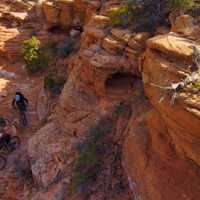
The Magnificent 7, or Mag-7, is a thrilling trail network located near Moab, Utah, known for its incredible mountain biking opportunities. This interconnected system of singletrack trails spans approximately 26 miles (42 km) and takes riders through the awe-inspiring desert landscapes of the region. The Mag-7 trail features a mix of slickrock, sandstone ledges, and flowy dirt sections, offering riders varying levels of difficulty and technical challenges.
The Moab Brands Trail, located near Moab, Utah, is a popular trail system that offers a diverse range of recreational activities for outdoor enthusiasts. Named after the cattle brands of Bar-M, Circle-O, Rockin-A, and Bar-B, the trail network covers over 30 miles (48 km) of interconnected singletrack and doubletrack trails suitable for mountain biking, hiking, and trail running. Featuring a mix of slickrock, sandy terrain, and rolling hills, the Moab Brands Trail caters to various skill levels, from beginner to advanced.
The Raptor Route Trail, located in Moab, Utah, is a new local favorite. This blue square intermediate trail is a 12 -mile (19 km) loop trail features a blend of slickrock, sandy sections, and rolling terrain, providing mountain bikers, hikers, and trail runners with a moderate challenge. The Raptor Route Trail takes visitors through picturesque scenery, including red rock formations and captivating views of the Abajo, Henrys, and La Sal Mountain ranges. The Raptor Route Trail is an excellent option for those seeking a more peaceful and less crowded adventure in the heart of Utah's red rock country. The Raptor Route combines Eagle Eye, Hawks Glide, Falcon Flow, and Kestrel Run.
The San Juan Huts Trail is a unique and adventurous multi-day route located near Moab, Utah, that offers an immersive backcountry experience for mountain bikers and hikers. This extensive trail system stretches over 215 miles (346 km) between Moab, Utah, and Telluride, Colorado, traversing diverse landscapes such as high desert plateaus, alpine forests, and majestic mountains. Along the route, visitors will find a series of rustic huts strategically placed to provide shelter, basic amenities, and a memorable overnight stay. The San Juan Huts Trail offers varying levels of difficulty, from moderate to challenging.
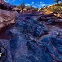
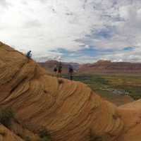
The Slickrock Trail, located in Moab, Utah, is a world-famous mountain biking and hiking trail that offers an unforgettable adventure amidst the region's striking red rock landscape. This 10.5-mile (16.9 km) loop trail consists primarily of smooth Navajo sandstone, giving it the "slickrock" name, and presents a unique and challenging experience for outdoor enthusiasts. With steep inclines, sharp descents, and technical sections, the Slickrock Trail demands a high level of skill and fitness from its visitors.
The Whole Enchilada Lower Section is a thrilling and challenging portion of the world-renowned Whole Enchilada Trail located near Moab, Utah. This lower section, which covers approximately 20 miles (32 km) of the full 34-mile (54 km) route, showcases Moab's diverse and stunning landscapes, taking mountain bikers and hikers through a mix of slickrock, sandstone ledges, and flowing singletrack. The trail offers a variety of technical challenges and breathtaking views of the La Sal Mountains, red rock canyons, and the Colorado River.
Why You Should Choose Moab, Utah For Your Next Mountain Bike Vacation:
There are several reasons why a mountain biker might choose to ride the Moab canyons for their next vacation.
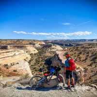
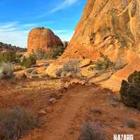
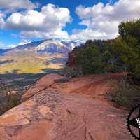
Spectacular Scenery: Moab is renowned for its breathtaking natural landscapes, including red rock canyons, towering mesas, and stunning desert vistas. Mountain biking in this unique environment allows riders to immerse themselves in the beauty of the region.
World-Class Trails: Moab is home to an extensive network of world-class mountain biking trails. From beginner-friendly routes to challenging technical descents, there is something for every skill level. Trails like the Slickrock Trail, Porcupine Rim Classic, and the Whole Enchilada are famous among mountain bikers worldwide.
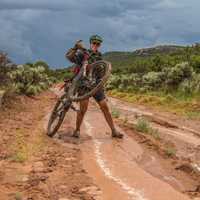
Diverse Terrain: Moab offers a wide variety of terrain for mountain biking. Riders can navigate through slickrock formations, pedal along sandy trails, tackle rocky descents, and navigate technical sections. The diverse landscape keeps the riding experience exciting and engaging.
Accessibility: Moab is easily accessible, located in southeastern Utah and within a day's drive of many major cities in the western United States. The proximity to major airports and the availability of bike rental and shuttle services make it convenient for visitors.
Outdoor Adventure Hub: Moab is a popular destination for outdoor enthusiasts, offering a wide range of activities beyond mountain biking. Visitors can explore Arches National Park, Canyonlands National Park, go hiking, rock climbing, rafting, or even take a scenic flight over the area. The abundance of options makes it an ideal location for adventure seekers.
Mountain Biking Community: Moab has a thriving mountain biking community and is often regarded as a mecca for riders. The town hosts various mountain biking events and festivals throughout the year, creating a vibrant atmosphere and providing opportunities to connect with like-minded riders.
Overall, Moab's stunning scenery, world-class trails, diverse terrain, accessibility, outdoor adventure opportunities, and strong mountain biking community make it an attractive destination for anyone seeking an unforgettable mountain biking experience.
What Others Are Saying About Hazard County Shuttle
Went to get a shuttle from Poison Spider and they said to use Hazzard County. Called him up, got a shuttle at the END of the trail where we dropped off our vehicle. He took us to the beginning and we did the trail and came out right at our vehicle. 10/10. Fast and courteous. I wont use anyone else.
— Jason Ladd ⭐⭐⭐⭐⭐
We had a super great time with Geoff. He met us at 5:30a for the shuttle up to Mag 7. He was super friendly and was able to rattle off a surprising amount of helpful information at that early in the morning. No worries about the security of the bikes in the rack as we drove up - he uses a Velocirax and Thule bike rack trays. No complaints, would recommend!
— Joey Godiska ⭐⭐⭐⭐⭐
Went to Moab for Thanksgiving and my family had a fantastic day doing the Mag 5 trail with Hazard County Shuttles. I've never biked in Moab before and I was a little nervous about getting in over my head with two teenagers. Geoff spent a lot of time talking to me about route options and gave me great advise on how to strike the right balance between doing an epic ride and keeping things safe. The Hazard County shuttle for the Mag 5 was super convenient compared to other shuttle options because you can get picked up at the Moab Brands trailhead instead of in town (this cuts out 9 miles on the road after the end of the ride). The price of the shuttle is also very reasonable, especially considering that ride that followed the shuttle was hands down the best time I've ever had on a bike.
— Dan Miller ⭐⭐⭐⭐⭐
We used Hazard County Shuttle service twice during our Moab visit and had great experiences both times. Geoff gave us helpful pointers for navigating the trails and the latest trail conditions so that we knew what to expect. There are other shuttle services in town for a similar price, but I think Hazard County Shuttle stands out due to the friendly service, clear communication, and trailhead pick-up. Highly recommended.
— Grant Bauer ⭐⭐⭐⭐⭐
BEST BIKE SHUTTLE IN MOAB! Jeff picked us up after three days of riding and couldn’t be nicer… on time, great price, bikes well secured and cared for, and he even shared tips on what to do in Moab. Outstanding service all-around! Would use them again in a heartbeat.
— Alistair Goodman ⭐⭐⭐⭐⭐
Geoff, with Hazard County Shuttle is amazing! We’ve been wanting to ride Moab for the longest time and heard about the great service you get with HCS. Geoff recommended some nice trails to ride, which we truly enjoyed. We received excellent service throughout our time pre- and post rides. He’s extremely knowledgeable about the trails, which added that extra comfort knowing we’d have a great time! If you’re considering riding Moab, go with Geoff at Hazard County Shuttle. Definitely will be using this service on return trips.
— Nelda Carrizales ⭐⭐⭐⭐⭐
I have had three separate great experiences with Hazard County Shuttle. Our shuttle driver Geoff was awesome! He was punctual, professional and just an all around cool guy. He gave us a lot of great tips on the best trails to ride on our visit. I would highly recommend this company.
— Tanner McCarty ⭐⭐⭐⭐⭐
Purchased 2 shuttle rides for Falcon Flow trails. Geoff was very communicative and accommodating to the changes in weather, attendance, and schedule. He met us promptly at the designated place and time. Very friendly and helpful as he shuttled us up to the highest part of the trail that was accessible due to weather conditions. He even waited for us at the next trailhead to get a sit-rep on the trails. By the time we got down to the trailhead and out the park, he just happened to be heading back into town and gave us an impromptu lift - it wasn't in the package but he did it anyway. So, for MOAB mtn biking, you can do a LOT worse than Hazard. They are a quality crew to go with!
— John Nguyen ⭐⭐⭐⭐⭐
Geoff was amazingly responsive and accommodating. As a long-time professional in the outdoor industry, I understand the customer service side of things quite well. Haz Co Shuttle knocked it out of the park. Will 100% use again!
— Christopher Marshal ⭐⭐⭐⭐⭐
I called Geoff in the morning and he was flexible and accommodating to add me to an afternoon shuttle. He has unique pickup locations and slightly different schedule times than most other Moab shuttle companies which I find more accommodating. Geoff is also knowledgeable, friendly and a great guy!! No doubt I'll be using Hazard County Shuttle again in the near future.
— Keith DeGryse ⭐⭐⭐⭐⭐
Went to get a shuttle from Poison Spider and they said to use Hazzard County. Called him up, got a shuttle at the END of the trail where we dropped off our vehicle. He took us to the beginning and we did the trail and came out right at our vehicle. 10/10. Fast and courteous. I wont use anyone else.
— Jason Ladd ⭐⭐⭐⭐⭐
We had a super great time with Geoff. He met us at 5:30a for the shuttle up to Mag 7. He was super friendly and was able to rattle off a surprising amount of helpful information at that early in the morning. No worries about the security of the bikes in the rack as we drove up - he uses a Velocirax and Thule bike rack trays. No complaints, would recommend!